

The White Mountains of New Hampshire provide more than just breathtaking scenery and renowned tourist sites. They are among the most popular hiking and climbing destinations in the country. The Appalachian Trail crosses Maine through the ridgelines of the Presidential and Franconia ranges, over the summit of Mt. Washington (the highest peak in the Northeast), and through a wide wilderness region on its trip from Maine to Georgia.
The AMC's Highland Center is a good base for hikers in the White Mountains, with a hostel, equipment, up-to-date route information, and guided walks for beginners and specialists. A hiker shuttle allows you to take longer trails without having to return to the same trailhead.
Not all of New Hampshire's mountains are in this northern range; there are also hikes and climbs in the state's southern region. Along with challenging multi-day walks, this list contains shorter hikes to waterfalls and even mountaintops that are excellent for families and individuals who are not interested in tough multi-day hikes.
With our selection of the best hiking trails near Portsmouth, New Hampshire, you can explore the state's spectacular scenery.
1). Mt. Washington: Ammonoosuc Ravine Trail

Image Source: https://www.theoutbound.com/
Address: Base Road, Bretton Woods, New Hampshire
The ascent of the Northeast's highest peak beside the Ammonoosuc River is one of the most rewarding hikes in the Presidential Range, revealing a sequence of waterfalls, cascades, and views that equal any other route up the mountain.
It's a full day's climb from the trailhead, which is immediately below the Mt. Washington Cog Railway's Base Station, to the summit, which is around nine miles round-trip. You'll pass Lakes of the Clouds and the AMC lodge on your way down from the peak. You can return to the trailhead by the Jewell Trail, which is a much simpler descent with its own spectacular vistas.
Whatever the weather is like at the base, note that the summit is never warm; Mt. Washington's weather is so extreme that Arctic technology is tested here, and it's where the world's highest land wind velocity was recorded. The weather can change in a second, and when clouds descend over the summit, visibility is reduced to nil.
2). Mount Monadnock
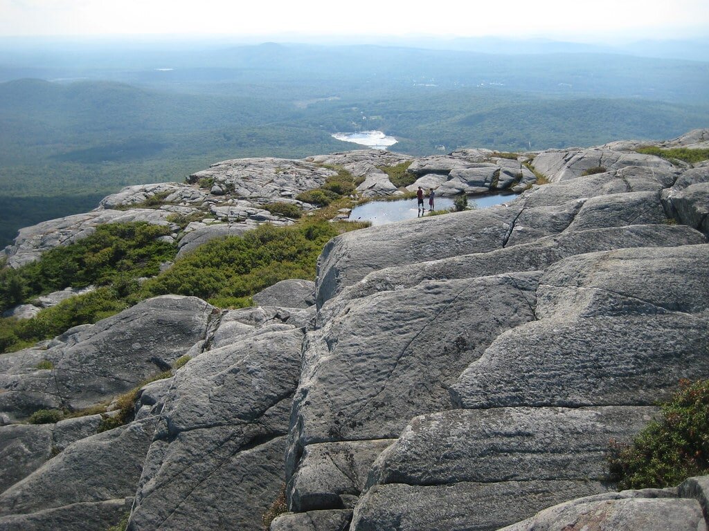
Image Source: https://www.flickr.com/
Address: 116 Poole Road, Jaffrey, New Hampshire
Monadnock, the world's most hiked mountain, stands alone in southwestern New Hampshire, where its rocky top affords 360-degree vistas that stretch as far as Boston on a clear day.
There are numerous hiking trails to choose from. The White Cross Trail, a four-hour round-trip hike through intermediate terrain, is the most popular. It starts at the Monadnock State Park entrance along US 101 in Jaffrey. The longer Pumpelly Trail, which is more challenging but more varied, climbs the opposite side of the mountain from the shores of Dublin Lake near Dublin, which is also accessible via US 101. The Pumpelly Trail is a six- to seven-hour round-trip hike that begins in the woods and ends with a climb over rocks and boulders as the trail rises and falls along an uneven ridge above the tree line.
Because the peak stands alone - it is 1,000 feet higher than any other mountain within 30 miles - it can be breezy, even on a hot day, and the weather can change quickly. Regardless of which trail you choose, the rocky top can be dangerous when wet, and fog can drop swiftly, making finding the trail nearly difficult.
3). Mount Willard

Image Source: https://www.visitwhitemountains.com/
Address: US 302, Crawford Notch, Bretton Woods, New Hampshire
This little mountain, which blocks the entrance to Crawford Notch, rewards climbers with one of the best vistas of the White Mountains below timberline. The track climbs through cool forests for just over three kilometers round-trip before emerging onto the cliffs at the summit.
You'll be treated to a panoramic view of Crawford Notch below you (and to wild blueberries in mid-summer). There's no better spot to see how glaciers withdrew and cut and scoured out New Hampshire's notches.
If you're hiking with kids—and this is a great family climb—be warned that the cliffs are steep and the drop is quick. There are two other shorter treks from the parking area beside Little Saco Lake, one around the lake and up to Elephant Head rock formation, and the other to Beecher Falls.
4). Basin-Cascades Trail

Image Source: https://www.youtube.com/
Address: Franconia Notch Parkway (US I-93/3), Franconia Notch, New Hampshire
It's unusual for a hiking trail to begin with two terrific kid-friendly attractions before you've even started climbing. The Basin is a massive pothole formed by a glacier cascade. The trail's formation is described on signage along the trail, and it's worth a stop even if you don't climb the trail that begins here.
A few yards further on lies one of the state's most appealing and approachable waterfalls, a long moderate cascade down a series of ledges that entice climbing or sitting to enjoy the view. Follow the route beside the falls to discover a slew of falls and cascades over flat ledges that appear to be designed for picnicking.
Kinsman Falls is about a half mile above the first cascades, and the slope then becomes steeper to Rocky Glen Falls. You can continue above this point, crossing a wooden bridge and climbing to Lonesome Lake, but the terrain becomes a little difficult for small legs.
5). Franconia Notch Ridge Trail
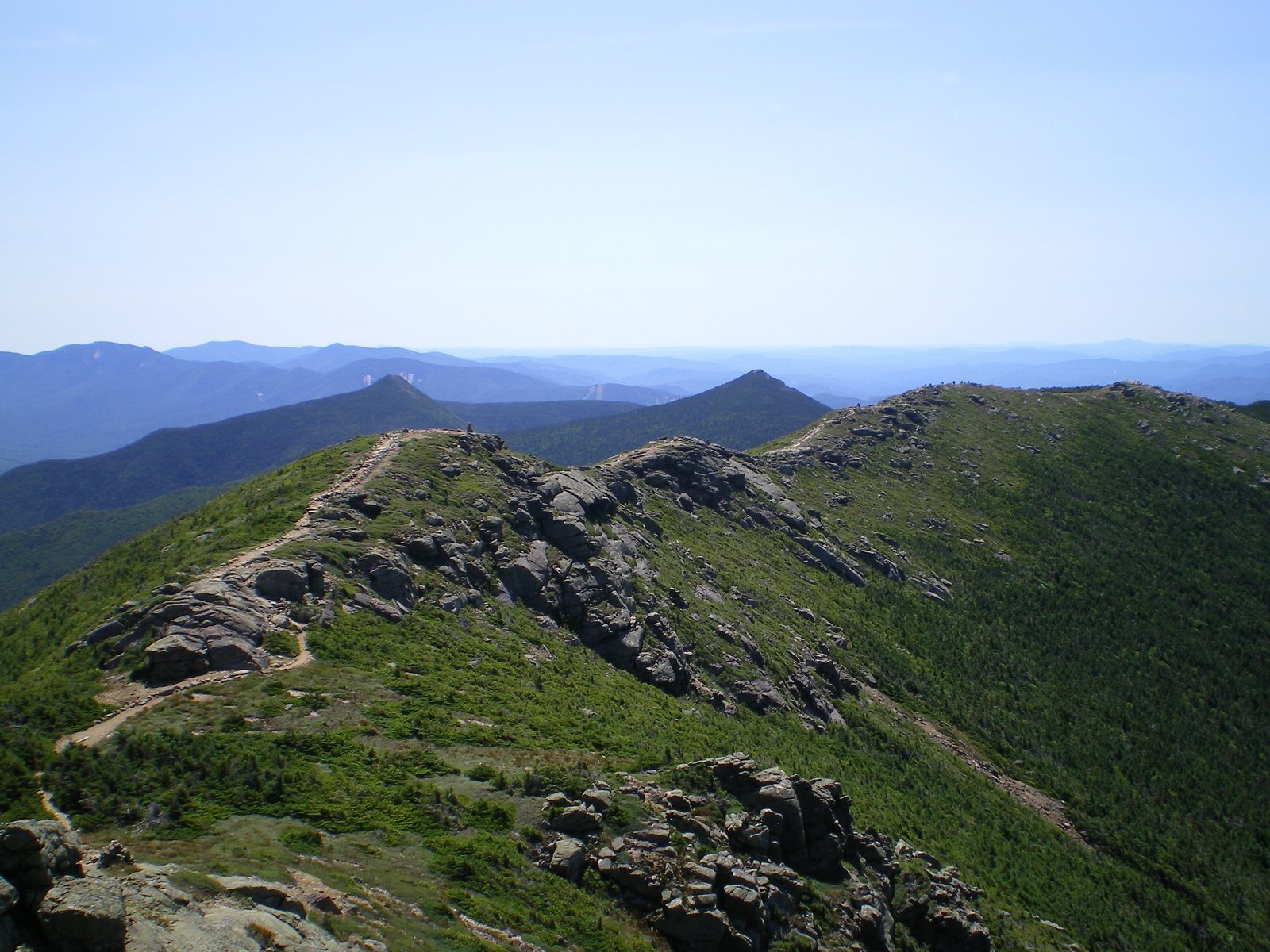
Image Source: https://en.wikipedia.org/
Address: Lafayette Campground, US I-93/3, Franconia Notch, New Hampshire
The eight-mile journey along the crest of the Franconia Ridge, while slightly shorter than the hike atop the Presidential Range, offers a comparable multi-peak experience, but with the added excitement of a knife-edge trail with mountain sides dropping down precipitously on each side.
This circle trek may be hiked in one day—around it's eight hours of hiking—or you can split it up with an overnight stay at the Greenleaf Hut. Three mountain peaks and a succession of waterfalls on the descent along Falling Waters Trail are further attractions, in addition to the stunning vistas down into Franconia Notch.
This final section of the circle from Cloudland Falls to Lafayette Campground, where the loop begins and ends, is a good shorter ascent appropriate for families. On a hot day, bring your bathing suit and cool off in one or more of the pools.
6). Thoreau Falls and Zealand Falls

Image Source: https://www.proteanwanderer.com/
Thoreau Falls, one of New Hampshire's lesser-known waterfalls, is a 4.8-mile journey, with a shorter option of stopping at the smaller Zealand Falls at 2.7 miles. In any case, stop at the AMC Zealand Falls Hut for a refreshing beverage and a glimpse of Zealand Notch from the veranda. It's a view that only hikers can see because there are no roads leading to this little-known notch.
Begin the hike at the end of Zealand Road, which branches off Route 302 between Twin Mountain and Bretton Woods. The trail's first two kilometers wind through coniferous trees and along the track of an old logging train before circling a pond. The Zealand Trail comes to an end at the intersection of the Ethan Pond and Twinway trails. To the right, Twinway climbs alongside Zealand Falls to the AMC hut and views of the deep U-shaped Zealand Notch.
To continue on to Thoreau Falls, turn left below Zealand Falls onto the woodland Ethan Pond Trail. The Thoreau Falls Trail is marked by a sign, and you'll soon emerge onto the ledges at the start of the falls. A succession of cascades, pools, and channels culminating in a 20-foot straight drop. A trail runs alongside the falls to the base, where you may see a distinct set of vistas.
7). Mt. Kearsarge Rollins Trail
Image Source: https://www.trailsunblazed.com/
Address: Rollins State Park, Warner, New Hampshire
Mt. Kearsarge, at 2,937 feet, can be climbed from either of two state parks. It's a little more than a mile of moderate hiking on the Winslow State Park side. Returning to the parking area can be made more interesting by taking the Barlow Trail from just below the summit and looping back down. The Barlow Trail is approximately 1.7 miles long, with ledges and other vistas along the way.
It's roughly a mile from the end of the road in Rollins State Park, on the side of the mountain, to the fire tower at the peak. You can take the Lincoln Trail from the same parking area for a more difficult but still brief climb to the peak.
When the tower is staffed in the summer and fall, the rangers frequently greet tourists. Mt. Kearsarge is just around 3,000 feet tall, but it stands alone, so the 360-degree vistas extend all the way to the White Mountains and into Vermont, as well as enclosing multiple lakes. You can take the Lincoln Trail from the same parking area for a more difficult but still brief climb to the peak. Don't get this mountain mixed up with the other Mt. Kearsarge near North Conway.
Hopefully, this post has helped you plan your next vacation for hiking near Portsmouth, New Hampshire.
No matter what kind of trek you're searching for; simple, challenging, or somewhere in between, waterfalls to mountaintops, New Hampshire has it all!
Are you looking for a hotel to stay in near Portsmouth, NH?
Minutes to downtown Portsmouth. The first hotel over the border from Portsmouth, NH.